Problem
Geospatial reporting inevitably requires reporting data on a map. SQL Server Mobile Report Publisher provides a set of maps out-of-the-box for authoring mobile reports. Often there is a need for custom maps which are not available in the limited set of maps available, so in this tip we will look at how to use custom maps in SQL Server Mobile Reports.
Solution
SQL Server Mobile Report Publisher provides options to use custom ESRI Shape files as maps for mobile reports development.
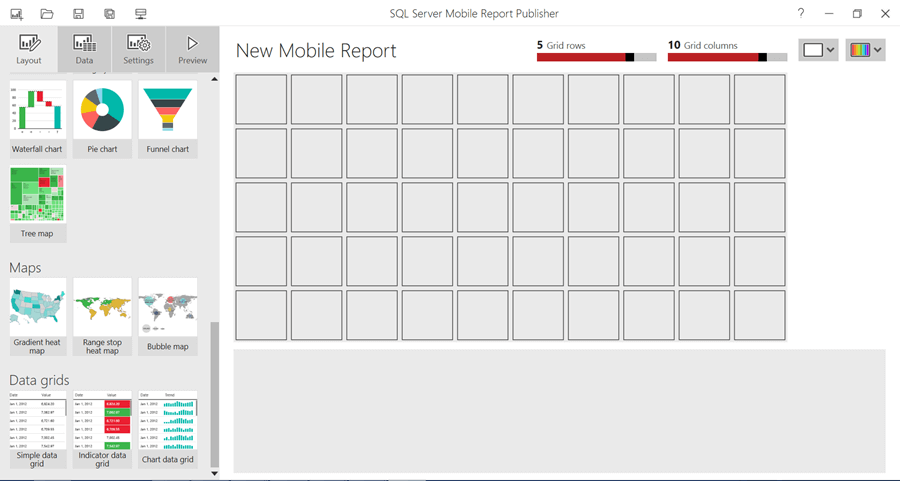
- Assuming that you have already installed SQL Server Mobile Report Publisher, open the application as shown below. In the maps section you should be able to see Geospatial Maps
- Drag any map on the grid and enlarge it for a clear view.
- Click on the Map dropdown, and you should be able to see the out-of-the-box maps. The Custom map button allows you to select any custom ESRI shapes that can be used as a map. An ESRI Shape file is a .SHP file for shape geometries and a .DBF file for metadata. These files are required to be in the same location and should have the same file name. You can read more about the specifications here.
- Click on the Custom Map button and select a .SHP and .DBF file of a custom map. You can download this sample shape from here.
- Once you have successfully opened the shape file, it will be applied to the control and you should be able to visualize the custom map.
.


In this way, any ESRI shape can be used as a custom map for a mobile report.
Next Steps
- You can explore QGIS tool to author custom GIS Shapes.
- Consider exploring this link to learn more about how to create your own ESRI Shapes to create custom maps.
- Read these other Reporting Services Maps Tips.

Siddharth has more than 14 years of experience in the IT Industry, with more than a decade of experience in Business Intelligence and Analytics, for clients banking, logistics, government, Media Entertainment, products, life sciences and other domains. He has been a lead architect for a portfolio of 40+ apps, containing apps in web, mobile, BI, Analytics, data warehousing, reporting, collaboration, CMS, NoSQL and other technologies. He has several certifications and is a published author for online and print-media publications, as well as the MSDN Library.
In his present role, he remains responsible for architecture design, technology stack selection, infrastructure design, 3rd party products evaluation and procurement, and performance engineering. These applications use technologies like Elasticsearch / Lucene, MongoDB, SharePoint 2013 and 2010, jQuery-based framework like Highcharts and GoJS, SQL Server and the Microsoft Business Intelligence stack (SSIS, SSAS, SSRS, MDX, PowerPivot, PowerView), jQueryMobile, Bootstrap, iOS xCode framework, and many others.
- MSSQLTips Awards: Champion (100+ tips) – 2018 | Author of the Year – 2017 | Author Contender – 2016, 2018-2019