Problem
Some SQL Server DBAs complain that it is hard to start working with the Spatial Data Types without using a real world example. In today’s tip I am going to show how to find the distance between different cities using the SQL Server geography data type and Google Earth.
Solution
In this tip I am using SQL Server 2012, but this sample code should work with SQL Server 2008 or later. Earlier versions of SQL Server did not include the geography data type. Another tool that I’ve installed for this tip is Google Earth, but you can use other tools like findlatitudelongitud.com, itouchmap.com, etc.
Getting started with the geography calculations in SQL Server
Let’s first create a table to store the cities and coordinates:
CREATE TABLE [dbo].[CitiesWorld](
 [Id] [smallint] IDENTITY(1,1) NOT NULL,
 [City] [nchar](40) NULL,
 [Coordinates] [geography] NULL,
 CONSTRAINT [PK_CitiesWorld] PRIMARY KEY CLUSTERED
(
 [Id] ASC
)WITH (PAD_INDEX = OFF, STATISTICS_NORECOMPUTE = OFF, IGNORE_DUP_KEY = OFF, ALLOW_ROW_LOCKS = ON, ALLOW_PAGE_LOCKS = ON) ON [PRIMARY]
) ON [PRIMARY] TEXTIMAGE_ON [PRIMARY]
GO
The only special thing in this example is that we are using a geography data type in the column named Coordinates. In this example we are going to work with 2 cities: Cochabamba (where I live) and London.
Using Google Earth Data
In order to find he coordinates for each city, I am going to use Google Earth
Now let’s move to Cochabamba, Bolivia. I am going to zoom in until I can see the airport:
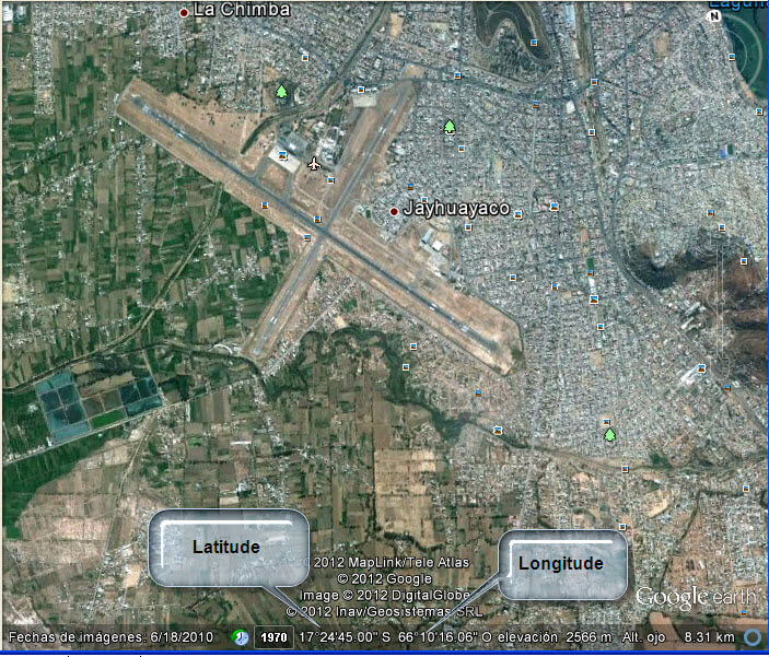
Verify the latitude and longitude. As you can see in the picture, the Latitude of Cochabamba is 17°24’45.00 S and the Longitude is 66°10’16.06” W.
We need to convert this coordinates to a SQL Server format. There are many ways to do this. In this example I am going to use the earthpoint.us site.
In the site write the latitude and longitude and press the Calc button:

Insert Latitude and Longitude Data
Let’s insert the “Degrees Lat Long” information in our CitiesWorld table:
INSERT INTO [dbo].[CitiesWorld] ([City],[Coordinates])
VALUES ('Cochabamba', geography::STGeomFromText('POINT(-66.1711278 -17.4125)', 4326));
GO
Now let’s move to London:

I am going to Zoom in until I can see the airport:

The latitude is 51°30’23.29” N and the Longitude is 00°01’39.13 E”.
If we repeat the step 5 and 6 with the London coordinates we will have the following results:

Now we are going to insert this information in the table:
INSERT INTO [dbo].[CitiesWorld]([City],[Coordinates])
VALUES('London', geography::STGeomFromText('POINT(0.0275361 51.5064694)', 4326));
GO
Create Stored Procedure to Calculate Distance
Now, let’s find the distance by plane between London and Cochabamba. To do this I created the following stored procedure:
CREATE PROCEDURE Distance
@cityor varchar(50),@citydest varchar(50),@unit varchar(5)
as
   declare @or geography, @dest  geography
   SET @or = (select coordinates from [dbo].[CitiesWorld] where city=@cityor)
   SET @dest = (select coordinates from [dbo].[CitiesWorld] where city=@citydest)
IF @unit='miles'
 SELECT @or.STDistance(@dest)/1609.344
ELSE
 --Else show the distance in km
 SELECT @or.STDistance(@dest)/1000
The following procedure finds the distance between two points stored in the CitiesWorld table. This stored procedure is using the STDistance function. You can find the distance in Kilometers or Miles. To find the distance in miles use the following code:
EXECUTE Distance 'Cochabamba','London','miles'The distance between these two cities in miles is: 6186.99
In order to find the distance in kilometers, use this sentence:
EXECUTE Distance 'Cochabamba','London','km'The distance in Km is: 9957.01
Next Steps
- There are some pretty nice SQL Server functions to find the distance and areas using geography points. There are new applications created to find areas, perimeters and the distance between two points. If you want you can find distance between your home and your office and more.
- Review the following resources for more information:

Daniel Calbimonte is a Microsoft Most Valuable Professional, Microsoft Certified Trainer and Microsoft Certified IT Professional for SQL Server. He is an accomplished SSIS author, teacher at IT Academies and has over 10 years of experience as a QE and developer for SQL Server related software. He has worked for the government, oil companies, web sites, magazines and universities around the world. Daniel also regularly speaks at SQL Servers conferences and blogs.
- MSSQLTips Awards: Author of the Year Contender – 2015-2018, 2022, 2023 | Champion (100+ tips) – 2018